• You will need to login or register before you can post a message. If you already have an Agriville account login by clicking the login icon on the top right corner of the page. If you are a new user you will need to Register.

A Friendly USDA June Acreage/Stocks Report = Early Bottom in the Grain Markets?

Collapse
X
Collapse
 
  • Time
  • Show
Clear All
new posts
  • AgrivilleAdmin
    Administrator
    • Feb 2011
    • 1002

    A Friendly USDA June Acreage/Stocks Report = Early Bottom in the Grain Markets?


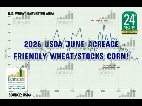
    USDA June acreage and stocks report was friendly.

    Stats Canada report bearish canola but friendly wheat.

    Long-term U.S. weather forecast of 3-4 degrees above normal in July a concern? Canadian Prairies remains wet!

    NEW 45Z calculator for low U.S. carbon corn is a WIN worth $100 - $135./acre!

    Crude oil breaks $70, $65 now in play!

    China bought more U.S. soybeans but volume light.

    U.S. suspends duties on Morocco fertilizers and USDA to fast-track U.S. fertilizer expansion provides a cushion long-term.
  • MoeAgostino
    Member
    • May 2025
    • 57

    #2
    How's your 2026 crops looking? Is too much rain or excess heat causing any problems?

    Comment

    • rumrocks
      Senior Member
      • Mar 2018
      • 1177

      #3
      As always, rain is the dealer and frost is the pit boss.

      Comment

      • Old Cowzilla
        Senior Member
        • Nov 2020
        • 1599

        #4
        Not sure where this excess heat is wearing a sweatshirt over t shirt every morning cut hay for 1/2 a day without the air turned on . Cool and wet just like April would be. Standing water in half our hay fields guess some is not going to be done for a while. Sister up at Swan got hit with more rain it's a freakin mess up there.

        Comment

        • ColevilleH2S
          Senior Member
          • May 2007
          • 1659

          #5
          Do any satellites have the ability to map and calculate the % of Western Canadian cropland that is currently underwater? I assume it would be a simple thing to detect from orbit. It seems odd that no one is publicly sharing this data.

          Comment

          • makar
            Senior Member
            • Jan 2007
            • 1697

            #6
            Originally posted by ColevilleH2S View Post
            Do any satellites have the ability to map and calculate the % of Western Canadian cropland that is currently underwater? I assume it would be a simple thing to detect from orbit. It seems odd that no one is publicly sharing this data.
            That wouldn't be politically correct.

            Comment

            • wrongway
              Senior Member
              • Jun 2021
              • 259

              #7
              Originally posted by ColevilleH2S View Post
              Do any satellites have the ability to map and calculate the % of Western Canadian cropland that is currently underwater? I assume it would be a simple thing to detect from orbit. It seems odd that no one is publicly sharing this data.
              there are a lot of satelites measureing every single little thing, and you know food production is high on the list. the entities collecting this data and selling it or using it for policy sure as heck don't want farmers knowing what is being collected and how its being used. Don't think for a second that the cargills of the world know to the tonne what the likely production will be and they are figuring out how to get the last nickel out of every sale. PROVINCIAL AND PRIVATE CROPS INSURANCE will be scrutinizing every acre for to wet to seed or for not seeded and reported as seeded. as they say its a small club and we ain't in it.
              Don't forget all the data that john deere is collecting, oh but they aren't selling it...lol.

              Comment

              • Reply to this Thread
              • Return to Topic List
              Working...