This website uses tracking tools, including cookies. We use these technologies for a variety of
reasons, including to recognize new and past website users, to customize your experience, perform
analytics and deliver personalized advertising on our sites, apps and newsletters and across the
Internet based on your interests.
You agree to our and by clicking I agree.
You will need to login or register before you can post a message. If you already have an Agriville account login by clicking the login icon on the top right corner of the page. If you are a new user you will need to Register.
Pour southern sk
Collapse
Logging in...
Welcome to Agriville! You need to login to post messages in the Agriville chat forums. Please login below.
I dont know but it seems like when they forcast huge amounts of rainfall or big snowfall dumps they dont happen. I would be more worried if they didnt forcast it thats when the bad ones usually hit. If its right though sf3 will go berserk.
The satellite looks scarey for today. Last night Weyburn and Wilcox had radar over them for awhile, but I haven't heard about rainfall amounts. Regina area just got missed last night. Hope this front moves on quickly, without the dire predictions of Weathernetwork. Two days ago they predicted about 2 inches today, close to three tomorrow and more after that. Can't happen, real farmers have faith - right?
well we finally got some rain here we missed just about all the rain in june, hopefullly we get some more out of this system 7mm so far and raining lightly
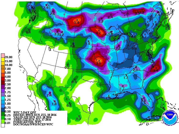
The image posted last Thurs suggest our area east of Edm would get 2 in the next week and as of this morning we are just over that so the practical solution is to build an ark.
That kind of rains KILLED the crops in 2010 in May, early June. Very different now. Drown outs and a MESS of haying for sure. Drainage ditches full again, impossible to mow for 3 years already.


Comment