
Originally posted by Sheepwheat
View Post
-
We gave up on them because they could not complete with spring wheat… and too often came back second growth with delayed maturity… not far off spring wheat. -
Same here , also too much winter kill and hard to get seeded before Sept 15.Originally posted by TOM4CWB View Post
When it worked it was good .
Agree with Tom , the new HRSW varieties can actually outperform winter wheatComment
-
With prices where they are most crops show a profit if costs are kept in line. I’d like to see crops other than canola as good of a margin so we’re not chained to that one trick pony. I don’t know about the rest of you guys but country here is half canola.Originally posted by AlbertaFarmer5 View PostComment
-
Aside from fall rye, which is a friggin weed, I've yet to see a fall seeded crop that can handle low to non-existent snow packs with extreme cold, and chronically low fall moisture for establishment which are both common here.Originally posted by Sheepwheat View Post
June moisture is the make or break for all crops here. If its cooler, and preferably cooler and wetter you can grow a winner. If July heat and shotgun shower season shows up early like it did last year everything withers and dies.Comment
-
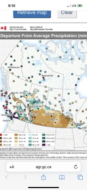
It’s a big area dry
Hopefully moisture starts coming regularly in the south ….
Comment
-
furrow
could you put up the same map for a year earlier and for 2019?Comment
-
-
I could not pull that up on that site . Just 2-3 year rolling , not year specific .Originally posted by bucket View Post
Maybe someone else can show that ?Comment
-
Here; you can play with the departure all the way back to 2013
https://search.open.canada.ca/openmap/7b817d93-f34d-4aa8-8658-d9abe9d84a8fComment
-


- Reply to this Thread
- Return to Topic List
Comment